GIS-toepassingen in onderzoek naar buitenplaatsenlandschappen
DOI:
https://doi.org/10.7480/knob.115.2016.3.1404##submission.downloads##
Samenvatting
The central theme of this article is the application of Geographic Information Systems, gis for short, as an instrument for spatial research into historical country estate landscapes aimed at increasing knowledge about historical layout, spatial coherence and development over time. This kind of research can focus on individual country estates in their immediate surroundings (house, garden, park, landscape), but can also be applied at the regional scale, where ensembles of several country estates are looked at in conjunction with their landscape context. gi s is generally seen as a powerful instrument for geographic data processing and cartography; its analytical merits are often overlooked. There are national and international examples of historical– geographical, landscape–archeological and landscape–architectural research in which the analytical qualities of gis have been used to acquire and enrich historical knowledge. Although there has always been and still is considerable interest in country estate landscapes, gis has been used only occasionally in this kind of research and very little has been written about it.
This article seeks to demonstrate the potential of gi s in this kind of research with reference to a number of applications in country estate research inside and outside the Netherlands, thereby contributing to the development and dissemination of knowledge in this field and helping to fill the knowledge gap between country estate research and the possibilities afforded by geoinformation technology.
To this end it describes and illustrates some of the ways in which gis can be used as a research instrument. These include data gathering, the use and processing of available analogue and digital sources as well as cartometric source analysis, measurement and correction of deviations in historical cartographic material in the interests of reconstruction. gis-based analyses of the spatial structure and coherence over time from horizontal (from inside) and vertical (from above) perspectives feature prominently in the article, together with different forms of representation such as maps, virtual landscapes and 3D prints.
The article shows that the use of the processing power of computers, in combination with inventive data gathering and modelling, analysis and visualization in an interactive process with the user, makes it possible to acquire and enrich information and knowledge about historical country estate landscapes. gis effectively extends the researcher’s observation via measurements, simulations and experiments, and opens new perspectives on the situational and cultural-historical aspects of country estates, which can play a part in value assessment and decisions regarding the use and management of these living green monuments.
Referenties
Voorbeelden van historisch-geografisch onderzoek met gis zijn: I. Gregory, A Place in History. A Guide to Using gis in Historical Research, Colchester 2002; E. Heere, gis voor historisch landschapsonderzoek. Opzet en gebruik van een historisch gis voor prekadastrale kaarten, Utrecht 2008. Voor archeologie: V.L. Gaffney en Z. Stančič, gis Approaches to Regional Analysis. A Case Study of the Island of Hvar, Ljubljana 1991; D. Wheatley en M. Gillings, Spatial Technology and Archaeology. The Archaeological Applications of gis, New York 2002. Voor landschapsarchitectuur: S. Nijhuis, ‘gis-Based Landscape Design Research. Exploring Aspects of Visibility in Landscape Architectonic Compositions’, in: D.J. Lee, E. Dias en H. Scholten (red.), Geodesign by Integrating Design and Geospatial Sciences, themanummer GeoJournal Library 111 (2014), 193-217; S. Nijhuis, gis-Based Landscape Design Research. Stourhead Landscape Garden as a Case Study, Delft 2015.
Enkele bekende voorbeelden van buitenplaatsenlandschappenonderzoek in Nederland zijn: A.G. Bienfait, Oude Hollandsche tuinen, ’s-Gravenhage 1943; R. van Luttervelt, De buitenplaatsen aan de vecht, Lochem 1948; W. Kuyper, Dutch Classicist Architecture. A Survey of Dutch Architecture, Gardens and Anglo- Dutch Architectural Relations from 1625 to 1700, Delft 1980; H.W.M. van der Wyck, De Nederlandse buitenplaats. Aspecten van ontwikkeling, bescherming en herstel, Alphen a/d Rijn 1983; E. de Jong, Natuur en kunst. Nederlandse tuinen landschapsarchitectuur, 1650-1740, Bussum 1993; V. Bezemer Sellers, Courtly Gardens in Holland 1600-1650, Amsterdam 2001; Y. Kuiper en B. Olde Meierink (red.), Buitenplaatsen in de Gouden Eeuw. De rijkdom van het buitenleven in de Republiek, Hilversum 2015.
Buitenplaatsenlandschappenonderzoek wordt hier gezien als een interdisciplinair werkveld waarin onder anderen landschapsarchitecten, historisch geografen en historici samenwerken.
P. Hendriks en H. Ottens (red.), Geografische Informatie Systemen in ruimtelijk onderzoek, Assen 1997, 9.
M.J. Kraak en F. Ormeling, Cartography. Visualization of Geospatial Data, Harlow 2003.
M. Kemp, The Science of Art. Optical Themes in Western Art from Brunelleschi to Seurat, New Haven 1990.
Gaffney en Stančič 1991 (noot 1), 15 e.v.; M. DeMers, gis (Computer System). www.britannica.com/EBchecked/topic/ 1033394/GIS (geraadpleegd 25 december 2013).
M. Lemmens, Geo-Information. Technologies, Applications and the Environment, Dordrecht 2011, 55-210.
Lemmens 2011 (noot 8), 55-201. 1
Voor landschapstuin Stourhead kon zodoende de ontwikkeling van het meer worden bestudeerd. Nijhuis 2015 (noot 1), 129. 1
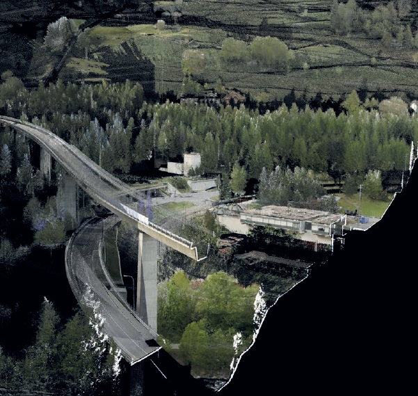
Het bestand is gebaseerd op een airborne LiDAR point cloud (Laser Imaging Detection And Ranging) met ca. 8 meetpunten per vierkante meter en kent een maximale afwijking in hoogte van 15 cm. 1
Bijvoorbeeld: www.pdok.nl; www.atlasleefomgeving.nl. 1
Bijvoorbeeld: www.planet.openstreetmap.org. 1
Voor uiteenzettingen over de kaart als historische bron wordt verwezen naar: C. Koeman, ‘Levels of Historical Evidence in Early Maps (With Examples)’, Imago Mundi 22 (1968), 75-80; E. van Mingroot, ‘De oude kaart als historische bron’, in: D. de Vries (red.), Kaarten met geschiedenis 1550-1800. Een selectie van oude getekende kaarten van Nederland uit de Collectie Bodel Nijenhuis, Utrecht 1989, 16-30; W.A. Ligtendag, ‘Oude kaarten als kenbron voor verleden en toekomst’, Historisch-Geografisch Tijdschrift 9 (1991) 3, 77-87. 1
Voor een typologie van bruikbare kaarten in dit type onderzoek zie: M. Seiler, ‘Auswertung historischer Pläne der Landschaftsgärten’, in: D. Hennebo (red.), Gartendenkmalpflege. Grundlagen der Erhaltung historischer Gärten und Grünanlagen, Stuttgart 1985, 120-140; M. Donkersloot-De Vrij, Topografische kaarten van Nederland. Een typologische toelichting ten behoeve van het gebruik van oude kaarten bij landschapsonderzoek, Alphen aan den Rijn 1995. 1
Voor een overzicht van cartometrische analysemethoden zie: Heere 2008 (noot 1), 72-78. 1
In Nederland volgens het Rijksdriehoekscoördinatenstelsel. 1
L.C. Halpern, ‘The Use of Paintings in Garden History’, in: J.D. Hunt (red.), Garden History. Issues, Approaches, Methods, Washington 1992, 59-78; D.S. Harris en D.L. Hays, ‘On the Use and Misuse of Historical Landscape Views’, in: M. Treib (red.), Representing Landscape Architecture, Londen 2008, 22-41. 1
E. Schmidt, ‘Gartendenkmalpflegerische Massnamen. Übersicht und Begriffserläuterungen’, in: D. Hennebo (red.), Gartendenkmalpflege. Grundlagen der Erhaltung historischer Gärten und Grünanlagen, Stuttgart 1985, 49-80; K. Grillner, ‘Experience as Imagined. Writing the Eighteenth-Century Landscape Garden’, in: M. Calder, (red.), Experiencing the Garden in the Eighteenth Century, Oxford 2006, 37-64. 2
Nijhuis 2015 (noot 1), 141-143. 2
C. Currie, Garden Archaeology. A Handbook, Bootham 2005. 2
Het gebruik van modellen als basis voor kennisverwerving is een gangbare praktijk in wetenschap en technologie. Zie C.P. Bertels en D. Nauta, Inleiding tot het modelbegrip, Bussum 1969. Naast beschrijvende zijn er ook procedurele modellen. Dit zijn modellen die processen kunnen simuleren op basis van geprogrammeerde procedures en algoritmen. Deze spelen echter nog nauwelijks een rol in buitenplaatsenlandschappenonderzoek en worden daarom buiten beschouwing gelaten. 2
Z. Li, Q. Zhu en C. Gold, Digital Terrain Modelling. Principles and Methodology, New York 2005; R. van Lammeren, ‘Geomatics in Physiognomic Landscape Research. A Dutch View’, in: S. Nijhuis, R. van Lammeren en F. van der Hoeven (red.), Exploring the Visual Landscape. Advances in Physiognomic Landscape Research in the Netherlands, Amsterdam 2011, 73-97. 2
G. Langran, Time in Geographic Information Systems, Londen 1992; I. Gregory en P.S. Ell, Historical gis. Technologies, Methodologies, and Scholarship, Cambridge 2007. 2
Nijhuis 2015 (noot 1), 132-134, 147 e.v. 2
M. Antrop, Perspectieven op het landschap. Achtergronden om landschappen te lezen en te begrijpen, Gent 2007. Hoewel het hier gaat om een kunstmatig onderscheid helpt het ons om grip te krijgen op de conceptuele, methodische en technische verschillen. 2
Zie voor een uitwerking van een buitenplaatsenlandschappentypologie: G. Verschuure- Stuip en H. Renes, ‘Hollandse buitenplaatsenlandschappen en hun relatie met het landschap (1609-1672)’, in: Kuiper en Olde Meierink 2015 (noot 2), 44-65. 2
Meer achtergronden zijn te vinden in: S. Nijhuis, ‘Visueel landschapsonderzoek. Methoden en toepassingen van visueel-ruimtelijke analyse met gis’, in: W. Simons en D. van Dorp (red.), Praktijkgericht onderzoek in de ruimtelijke planvorming. Methoden voor analyse en visievorming, Wageningen 2014, 139-167. 2
Tandy introduceerde de term ‘viewshed’ (letterlijk: zichtbekken) naar analogie van ‘watershed’ (waterbekken) en noemde het een nuttige methode om de ruimtelijke opbouw van het landschap vanuit ooghoogte te analyseren. C.R. Tandy, ‘The Isovist Method of Landscape Survey’, in: C.R. Murray (red.), Methods of Landscape Analysis, Londen 1967, 9-10. 3
Zie in dit verband bijvoorbeeld: De Jong (noot 2); C.M. Steenbergen en W. Reh, Architectuur en landschap. Het ontwerpexperiment van de klassieke Europese tuinen en landschappen, Bussum 2003. 3
G. Fanelli en M. Fanelli, Brunelleschi’s Cupola. Past and Present of Architectural Masterpiece, Florence 2004, 53-58; C. Bertsch, Villa, Garten, Landschaft. Stadt und Land in der florentinischen Toskana als ästhetischer und politischer Raum, Berlijn 2012. 3
Nijhuis 2015 (noot 1), 228 e.v. 3
Nijhuis 2015 (noot 1), 228 e.v. 3
A. de Boer e.a., ‘Virtual Historical Landscapes’, in: Nijhuis, Van Lammeren en Van der Hoeven 2011 (noot 23), 184-203. Amsterdam 2011, 184-203. 3
Zie bijvoorbeeld: E. Sanderson, Mannahatta. A Natural History of New York City, New York 2009; J. Rekitte en P. Paar, ‘Past Pictures. Landscape Visualization with Digital Tools’, in: T. Bloemers et al. (red.), The Cultural Landscape & Heritage Paradox, Amsterdam 2010, 309-320. 3
D. DiBiase, ‘Visualization in the earth sciences’, Earth and Mineral Sciences 59 (1990) 2, 13-18. 3
S.M. Ervin, ‘Digital Landscape Modelling and Visualization. A Research Agenda’, Landscape and Urban Planning 54 (2001), 49-62. 3
S. Nijhuis en M. Stellingwerff, ‘3DModels in Landscape Architecture’, in: J. Breen and M. Stellingwerff (red.), Envisioning Architecture, Delft 2011, 197-208. 3
P.D. Riggs en D.J. Dean, ‘An Investigation into the Causes of Errors and Inconsistencies in Predicted Viewsheds’, Transactions in gis 11 (2007), 175–196. 4
H. Li en J. Wu, ‘Use and Misuse of Landscape Metrics’, Landscape Ecology 19 (2004), 389-399. 4
E. Lange, ‘The Limits of Realism. Perceptions of Virtual Landscapes’, Landscape and Urban Planning 54 (2001), 163–182; L. Bodum, ‘Modelling Virtual Environments for Geovisualization. A Focus on Representation’, in: J. Dykes, A. MacEachren en M. Kraak (red.), Exploring Geovisualization, Amsterdam 2005, 389-402. 4
Dit geldt voor ook toepassing van gis en andere digitale media in verwante onderzoeksvelden. Zie hiervoor: S. Nijhuis, ‘Nieuw gereedschap. Digitale media in de landschapsarchitectuur’, in: J. Vlug e.a. (red.), Over de noodzaak van ontwerpen, Velp 2013, 86-97.
Gepubliceerd
Citeerhulp
Nummer
Sectie
Artikelen
Licentie
Copyright (c) 2016 Steffen Nijhuis

Dit werk wordt verdeeld onder een Naamsvermelding 4.0 Internationaal licentie.